
This article comes to us from our friends at the Winchendon Springs Lake Association
At this year’s annual meetings of both the WSLA & MLPOA, our board did a presentation about Lake Monomonac’s water shed and the impact it has on not only flow and level, but also the quality of our water.
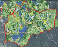 A watershed is an area of land that contains a common set of streams and rivers that all drain into a single larger body of water, in our case Lake Monomonac which is part of a large watershed known as the North Branch of the Millers River, also part of the larger Connecticut River watershed.
The North Branch of the Millers River starts in New Ipswich NH at Mountain Pond. It runs for 50.5 miles flowing thru Lake Monomonac eventually emptying in to the Connecticut River just downstream from Millers Falls, Massachusetts
Our direct watershed area is 12,448 acres in size. On the east side it starts in New Ipswich NH where a series of small pristine streams and ponds flows into and thru our lake. Starting at Mountain Pond along with Stump Pond free flows into and thru Island Pond, Mill Pond, forming the North Branch of Millers River flowing into Converse pond in Rindge before draining in to Lake Monomonac at our farthest north point between Millers & Wellington Rd. The North Portion of our watershed starts at Emerson Pond, which flows in to Crowcroft then into Little Crowcroft Pond and into our lake on the north west Between Wellington Rd and Heron Point Rd. In addition to these larger bodies of water entering our lake there are 15 other small streams or inlets that feeds our lake like Lord Brook on the 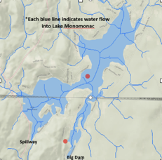 west side.
As you can imagine this is a lot of free-flowing water entering into Lake Monomonac. In fact, our lakes water completely turns over a minimum of 3 times in a year. This in part contributes to the difficulty in managing the level of the lake and drawdowns.
To the South there are the only 2 outlets, one on West Monomonac which is a large spillway that has a 12 foot area with 2 feet of removable boards. The main Big Dam located at the junction of Lakeview & Beachview is 6 ft wide and has 5 feet of removable boards. Once the spillway has reached its maximum discharge and shuts off, the water the only remaining outlet is the smaller capacity big dam which can have a difficult time keeping up with discharging the large volume of water entering our lake especially during above average rainy periods as we saw in the winter of 2018 when the lake rose a foot in a 24 hour period. If you have any questions or which to learn more about our watershed, please feel free to contact us.
Written by Renee Tambling, WSLA Treasurer
Comments are closed.